
Investing in Location Intelligence

Focusing on the Geospatial Technology and the Earth Observation Economy
This page is a preview of the full market research report for private equity, venture capital, corporate strategy, M&A and geospatial technology executives.
Based on the November 15, 2026 draft edition.
Why this research matters
Location intelligence is not one homogeneous software category. It is an interconnected economy of sensor observation and data assets, analytical software solutions, and implementation services. Investment opportunities and exit routes differ materially across these businesses.
The full report connects investment activity with a differentiated market taxonomy, investor participation, company profiles, transaction histories and exit strategies by both private equity and venture capital firms. This preview introduces the questions and structure without reproducing the proprietary directories, company-by-company funding records, investment tables or detailed conclusions that are available in the full report.
Who should purchase the report
- Private equity and growth-equity investors evaluating their current investment portfolios, add-on acquisitions and exits.
- Venture capital firms screening emerging geospatial, Earth observation and AI-enabled businesses.
- Geospatial technology leaders assessing competitors, capital flows, partners and potential investors or acquirers.
Inside the complete report
15 sections and seven appendices; the source draft spans 232 pages. The summaries on the following pages follow its section order.
Share the big news
Have you opened a new location, redesigned your shop, or added a new product or service? Don't keep it to yourself, let folks know.
Research Framework | Sections 01–04
01 About This Report
Introduces location intelligence as a decision-making foundation across sectors such as retail and insurance, logistics and transportation, critical infrastructure and enterprise analytics. Explains the purpose of mapping investment firms, portfolio companies, submarkets and transaction activity, and clarifies important limits in publicly disclosed funding data.
02 Executive Summary
Frames the investment opportunity across three primary pillars of data, software and services, and highlights differences between venture funding, growth capital and private-equity consolidation. The complete executive summary connects market structure, investment concentration, AI readiness, monetization and exit planning; detailed comparative findings are reserved for those that purchase the entire report.
03 Definitions & Observations
Defines location intelligence and explains why geography, proximity and location-based data attributes generate information that is not apparent from conventional tabular analysis found in spreadsheets alone. Discusses the specialist nature of the market and barriers to competing with established providers.
04 Market Taxonomy
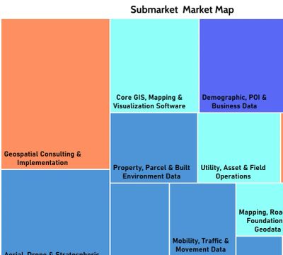
Introduces a classification of three pillars—Data & Observation, Software & Intelligence, and Services & Implementation—across 25 differentiated submarkets. This framework helps investors compare unlike businesses without conflating capital-intensive Earth observation remote sensing operations with software platforms or service firms.
The complete report provides the detailed taxonomy, company distributions and market-map exhibits.
Investment landscape | Sections 05–08
05 PE & VC Investments & Industry Sectors
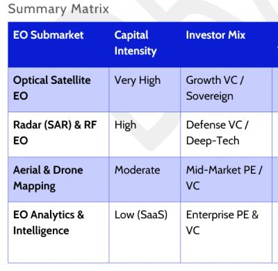
Reviews investor participation and the industry drivers behind geospatial investment, including utility and telecommunications modernization, government operations, AI, data integrity and defense-related intelligence. Illustrates why different financial investors favor different asset types and investment structures.
06 Investment Approaches, Value Creation, and Exit Planning
Examines buy-and-build strategies, digital infrastructure modernization, Earth observation monetization, and the growing importance of trustworthy data for AI applications. It considers recurring revenue, proprietary data, workflow integration and capital intensity as distinct value-creation factors.
07 Earth Observation Market Investment Analysis
Surveys investment patterns across satellite imagery, specialized sensing and related intelligence businesses. The analysis distinguishes satellite infrastructure economics from downstream data products and services, and addresses how investor expectations vary by funding stage and business model.
08 Geospatial Technology Investment Analysis
Extends the investment lens beyond space-based observation to location intelligence software, enterprise applications, data services and implementation businesses. It examines why recurring revenue, customer integration and sector specialization can influence investment and acquisition interest.
In the full report: investor and company examples, comparative sector analysis and more detailed discussion of investment theses.
Evidence and market signals | Sections 09–12
09 Recent PE & VC Transactions and Technology Impacts
Provides a transaction-oriented view of recent investment activity and the technologies influencing competitive positioning. It connects financing and acquisition developments with changes in geospatial data delivery, analytics and AI-enabled capabilities.
10 Submarket Category Investment Tables
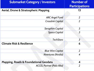
Organizes disclosed investment information using the report’s 25-submarket framework. These tables help readers identify patterns by category while respecting the distinction between funding rounds, transaction values and undisclosed activity. The underlying tables are intentionally excluded from this preview.
11 Investment Summary Charts
Presents visual comparisons of reported investment activity and market categories. The full charts support exploration of relative concentrations, period-over-period changes and the effect of large transactions on reported totals.
12 Initial Public Offerings & Public Listing Transactions (2026)
Reviews public-listing activity and conditional prospects in a market where acquisitions and private ownership remain important. It also examines how emerging AI interfaces and technology shifts may affect the narratives presented to public-market investors.
In the full report: transaction detail, categorized exhibits and the context needed to interpret reported figures responsibly.
Strategic interpretation | Sections 13–15
13 Investments by Submarket
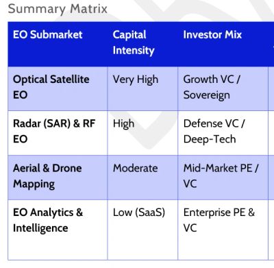
Compares investment activity across differentiated geospatial submarkets and discusses patterns that may matter to financial sponsors and corporate development teams. It emphasizes that reported financing is not a proxy for total market size or company performance.
14 Exit Strategies in Geospatial Technology
Examines strategic acquisitions, secondary buyouts and public-market pathways. The analysis considers factors such as recurring revenue, defensible data, market consolidation and potential buyer fit, while distinguishing realized transactions from possible future exits.
15 Contact Information
Provides the author’s professional background and information about follow-on market intelligence, independent research and strategic advisory services.
Why the full analysis is useful
- Screen market segments before committing to company-level diligence.
- Connect potential targets to known investors and adjacent acquisition activity.
- Assess how AI, cloud-native analytics and access protocols may change competitive positioning.
- Build a more structured view of investment pathways and possible exit considerations.
The report is an evidence-based market map for informational use, not an investment recommendation. Publicly disclosed records are incomplete and not uniformly comparable.
Research appendices | Appendices 1–7
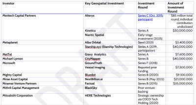
The appendices are a central part of the full report’s research utility. They let readers move from a market thesis to the companies, investors and transactions that is unique in market research. No past research on geospatial technology presents this information in as complete a reference guide herein. This preview describes their purpose without reproducing the proprietary compiled records.
Appendix 1 — Investor Directory
A reference directory of investment firms participating in the geospatial and Earth observation economy. Designed to help readers identify potential financial sponsors and investigate investment focus.
Appendix 2 — Investments by Each Investor
Organizes the relationships between investors and their geospatial holdings, supporting comparisons of portfolio exposure, thematic concentration and investment activity.
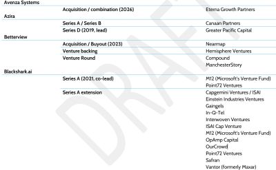
Appendix 3 — Geospatial Technology Companies and Their Investors
Provides the reverse lookup: company-to-investor relationships. Particularly useful when evaluating financing history, identifying backers of potential acquisition targets and mapping competitive portfolios.
Appendix 4 — Geospatial Company Directory
A structured company reference that supports market discovery, peer identification and preliminary target screening across the report’s geospatial submarkets.
Appendix 5 — Acquisition, Exit and Merger Summary
A transaction reference covering acquisitions, exits and mergers. Its purpose is to support review of consolidation, strategic buyers and ownership transitions, including distinctions between announced and completed deals.
Appendix 6 — Submarket Category Definitions
Definitions for the taxonomy used throughout the report. They help readers compare like-for-like businesses and interpret why individual companies are assigned to particular market segments.
Appendix 7 — Company Reference Index
An index for navigating company references throughout the full report and its supporting analysis.
What this preview deliberately withholds
- The complete investor directory and investment-by-investor listings.
- Company-level investor mappings and the full geospatial company directory.
- Detailed acquisition and exit records, investment tables and analytical charts.
- The full investment interpretations, category comparisons and supporting examples.
Those compiled research assets—and the ability to cross-reference them are the primary value of the paid edition.
Access the complete research
From industry overview to actionable market mapping
The complete report is designed for investment screening, competitive intelligence, corporate development and strategic planning. It combines a consistent market taxonomy with investor and company directories, financing records, transaction summaries and analysis of value creation and exit pathways.
For investors
Use the full report to identify investable market segments, map financial sponsors, locate relevant companies and develop informed follow-up diligence questions.
For geospatial technology companies
Use the research to understand the capital and competitive environment, assess partnership or acquisition landscapes and inform strategic positioning.
Request the full report
Click the BUY NOW button below for purchasing the report.

INVESTING IN LOCATION INTELLIGENCE

This report maps the investment landscape of the location intelligence marketplace inclusive of geospatial technology and Earth observation (EO) satellites, and specifically the firms that are investing, which companies and submarkets attract capital, how investors create value, and where exits may occur. It brings together investor profiles, company directories, funding records, transaction summaries, and comparative tables and charts to support investment screening, research into potential partners and acquisition targets, and due diligence.

Investing in Location Intelligence
Geospatial Technology & the Earth Observation Economy